Showing posts with label Inequality. Show all posts

Thursday, March 5, 2020

New paper out: Disparities in travel times between cars and public transport

I am very glad to share our new paper looking at the travel time gap between private and public transport at high spatial and temporal resolutions. The study combines real-time traffic data, transit data, and travel demand estimated using Twitter data to compare this travel time gap in four cities (São Paulo, Stockholm, Sydney and Amsterdam).

Despite remarkable differences between these cities in terms of transportation networks, area, and population size, we found travel times of transit and vs. driving are surprisingly similar across cities: R < 1 for trips shorter than 3km, then increases rapidly but quickly stabilizes at 2 (figure below). Moreover, using public transport generally takes on average 1.4–2.6 times longer than driving a car. The share of area where travel time favors public transport over car use is also very small in all cities. As Giulio Mattioli noted on Twitter, these results 'would confirm that car dependence is much more than just a question of culture & attitudes'.

The paper is open access and it was written in collaboration with a great team led by Yuan Liao and Sonia Yeh at University of Chalmers, Sweden.

Liao, Y., Gil, J., Pereira, R.H.M. et al. Disparities in travel times between car and transit: Spatiotemporal patterns in cities. Scientific Reports 10, 4056 (2020). https://doi.org/10.1038/s41598-020-61077-0

Abstract:
Cities worldwide are pursuing policies to reduce car use and prioritise public transit (PT) as a means to tackle congestion, air pollution, and greenhouse gas emissions. The increase of PT ridership is constrained by many aspects; among them, travel time and the built environment are considered the most critical factors in the choice of travel mode. We propose a data fusion framework including real-time traffic data, transit data, and travel demand estimated using Twitter data to compare the travel time by car and PT in four cities (São Paulo, Brazil; Stockholm, Sweden; Sydney, Australia; and Amsterdam, the Netherlands) at high spatial and temporal resolutions. We use real-world data to make realistic estimates of travel time by car and by PT and compare their performance by time of day and by travel distance across cities. Our results suggest that using PT takes on average 1.4–2.6 times longer than driving a car. The share of area where travel time favours PT over car use is very small: 0.62% (0.65%), 0.44% (0.48%), 1.10% (1.22%) and 1.16% (1.19%) for the daily average (and during peak hours) for São Paulo, Sydney, Stockholm, and Amsterdam, respectively. The travel time disparity, as quantified by the travel time ratio R (PT travel time divided by the car travel time), varies widely during an average weekday, by location and time of day. A systematic comparison between these two modes shows that the average travel time disparity is surprisingly similar across cities: R < 1 for travel distances less than 3 km, then increases rapidly but quickly stabilises at around 2. This study contributes to providing a more realistic performance evaluation that helps future studies further explore what city characteristics as well as urban and transport policies make public transport more attractive, and to create a more sustainable future for cities

The relationship between travel distance and travel time ratio R (PT travel time divided by the car travel time)

Friday, November 29, 2019

Awarded research on historical inequality in Brazil


I am very proud to share that my friend and colleague at Ipea Pedro Souza has been awarded the Prêmio Jabuti for his book 'A History of Inequality: the concentration of top incomes in Brazil between 1926-2013'. The Prêmio Jabuti (the "Tortoise Prize") is the most prestigious literary award in the country. The book is based on his PhD thesis, which has already received two national awards btw.

If you read Portuguese, you can buy Pedro's book here, or download his PhD thesis here. There is a paper in English summarizing some of the key findings of his research. I've also posted the English abstract of his thesis below.


Souza, Pedro H. G. F. de. “A desigualdade vista do topo : a concentração de renda entre os ricos no Brasil, 1926-2013”, 12 de setembro de 2016. https://repositorio.unb.br/handle/10482/22005.

Abstract:
This dissertation uses income tax tabulations to estimate top income shares over the long-run for Brazil. Between 1926 and 2013, the concentration of income at the top of the distribution combined stability and change, diverging from the European and American patterns in the 20th century. Contrary to benign industrialization and modernization theories, there was no overarching, long-term trend. Most of the time the income share of the top 1% of the adult population fluctuated within a 20%--25% range, even in recent years. Still, top income shares had temporary yet significant ups and downs which largely coincided with the country's most important political cycles. The top 1% income share increased during the Estado Novo and World War II, then declined in the early post-war years and even more so in the second half of the 1950s. The 1964 coup d'état reversed that trend and income inequality rose back to post-war levels after a few years of military rule. The 1970s were marked by instability, but top income shares surged again in the 1980s. The share of the 1% then decreased somewhat in the 1990s and perhaps the mid-2000s. There were no real changes since then. In addition, this dissertation analyzes the concentration of income among the rich, provides international comparisons of top income shares, and contrasts the income tax series with estimates from household surveys. The income tax series are also used to compute “corrected” Gini coefficients which take into account the underestimation of top incomes in household surveys. The major research questions are comparative and historically oriented, and I argue in favor of an institutional interpretation of the results. The motivation for and implications of this approach are presented in the more theoretical chapters that precede the empirical analysis. In these chapters, I engage with the history of ideas about inequality and social stratification and highlight the long and heterogeneous tradition of studies about the rich and the wealthy. My main argument is that the academic and political concern with distributional issues flourishes when inequality is conceived in binary or dichotomous terms.

Friday, August 31, 2018

New paper out: Transport legacy of mega-events and the redistribution of accessibility to urban destinations


I'm glad to share that the 2nd paper of my thesis is now published. It will remain open access for the next 50 days. Downloaded it here.

This is the 1st empirical paper of my doctoral research. Two other empirical papers are currently under review, but you can read their preprints here and here. My theoretical paper is available here, in case you are looking to have some fun over the weekend.

Pereira, R. H. M. (2018). Transport legacy of mega-events and the redistribution of accessibility to urban destinations. Cities, 81, 45–60. doi:10.1016/j.cities.2018.03.013

Abstract:
Local governments increasingly justify the hosting of mega-events because of their legacy value, assuming that all local residents benefit from those events. Yet, little attention has been paid to the distributive question of who benefits from the transport legacy left by those events. This paper reflects on the delimitation of transport legacies and its social impacts in terms of how such developments can reshape urban accessibility to opportunities. It analyses the transformation in the transport system of Rio de Janeiro (Brazil) in preparation for the 2014 World Cup and the 2016 Olympic Games. That transformation involved substantial expansion in public transport infrastructure, followed by cuts in service levels and a reorganization of many bus lines to streamline the transport system. The paper examines whether those recent changes have increased the number of people from different income levels who could access Olympic sports venues and healthcare facilities by public transport within 15, 30, 60 and 90 min. The analysis uses a before-and-after comparison of Rio's transport network (2014–2017) and a quasi-counterfactual scenario to separate the effects of newly added infrastructure from the reorganization and cuts of transport services. The results show that the infrastructure expansion alone would have increased the number of people who could access the Olympic sports venues, but it would have only marginally improved people's access to healthcare facilities. Nonetheless, the findings indicate that the streamlined bus system have offset the benefits of infrastructure investments in a way that particularly penalizes the poor. The analysis of both the implemented changes to the public transport network and the counterfactual scenario show that the accessibility benefits from the recent cycle of investments and disinvestments in Rio generally accrued to middle- and higher-income groups, reinforcing existing patterns of urban inequality.

Monday, March 26, 2018

Transport legacy of mega-events and the redistribution of accessibility to urban destinations

Good news! The 2nd paper of my thesis is coming out of the oven \o/ . The paper has not been assigned to a journal issue yet, but here you go (pdf).

The paper engages with the literature on mega-events and urban development to understand the particularities of transport planning in Rio de Janeiro, conducted for almost two decades under a context of mega-events planning. It is argued in the study that evaluations of the impacts of mega-events on urban infrastructure should take into account the distributional effects of the transport legacies created by those events, looking particularly at how such transport developments reshape social and spatial inequalities in access to opportunities.

This is the first empirical paper of my thesis. Two other empirical papers are currently under review, but you can read their preprints here and hereMy theoretical paper is available herein case you are interested  or have sleeping problems .


Pereira, R. H. M. (2018). Transport legacy of mega-events and the redistribution of accessibility to urban destinations. Cities. doi:10.1016/j.cities.2018.03.013

Abstract:
Local governments increasingly justify the hosting of mega-events because of their legacy value, assuming that all local residents benefit from those events. Yet, little attention has been paid to the distributive question of who benefits from the transport legacy left by those events. This paper reflects on the delimitation of transport legacies and its social impacts in terms of how such developments can reshape urban accessibility to opportunities. It analyses the transformation in the transport system of Rio de Janeiro (Brazil) in preparation for the 2014 World Cup and the 2016 Olympic Games. That transformation involved substantial expansion in public transport infrastructure, followed by cuts in service levels and a reorganization of many bus lines to streamline the transport system. The paper examines whether those recent changes have increased the number of people from different income levels who could access Olympic sports venues and healthcare facilities by public transport within 15, 30, 60 and 90 min. The analysis uses a before-and-after comparison of Rio's transport network (2014–2017) and a quasi-counterfactual scenario to separate the effects of newly added infrastructure from the reorganization and cuts of transport services. The results show that the infrastructure expansion alone would have increased the number of people who could access the Olympic sports venues, but it would have only marginally improved people's access to healthcare facilities. Nonetheless, the findings indicate that the streamlined bus system have offset the benefits of infrastructure investments in a way that particularly penalizes the poor. The analysis of both the implemented changes to the public transport network and the counterfactual scenario show that the accessibility benefits from the recent cycle of investments and disinvestments in Rio generally accrued to middle- and higher-income groups, reinforcing existing patterns of urban inequality.

Monday, March 19, 2018

"Even wealthy families, good neighborhoods and two parents can’t protect black boys from racism"

The title is this blog post comes from Emily Badger (Twitter), who has written a great piece for the NYT, covering the latest study of Raj Chetty and colleagues. Using a unique dataset, the study shows that black men consistently earn less than white men, regardless of whether they're raised poor or rich. The full paper is here.

The study is part of The Equality of opportunity Project, an ambitious and groundbreaking project led by Chetty. I've posted about the project in this blog a few years ago.


Tuesday, October 3, 2017

The long-term effect of slavery on inequality today

According to a new working paper, 1800s slavery explains approximately 20% of income inequality in Brazil today. While the direction of the impact is not surprising, I'm impressed by its magnitude. I wonder how much investment in cash transfer programs would be necessary to achieve an effect of similar magnitude. Thanks John B. Holbein‏ for pointing to this study on Twitter.


Fujiwara, T., Laudares, H., & Caicedo, F. V. (2017). Tordesillas, Slavery and the Origins of Brazilian Inequality.

From the abstract:
"...To deal with the endogeneity of slavery placing, we use a spatial Regression Discontinuity framework, exploiting the colonial boundaries between the Portuguese and Spanish empires in current day Brazil. We find that the number of slaves in 1872 is discontinuously higher in the Portuguese side of the border, consistent with this power’s comparative advantage in this trade. We then show how this differential slave rate has led to higher income inequality of 0.103 points (Gini coefficient), approximately 20% of average income inequality in Brazil. To further investigate the role of slavery on economic development, we use the division of the Portuguese colony into Donatary Captancies. We find that a 1% increase in slavery in 1872 leads to an increase in inequality of 0.112. Aside from the general effect on inequality, we find that more slave intensive areas have higher income and educational racial imbalances and worse public institutions today"

ps. This paper also reminds me of this post on how presidential elections are impacted by a 100 million year old coastline in the USA. Hint: geology determined the distribution of productive land, which influenced the spatial distribution of African slaves which in turn influenced the electoral distribution. I'm not saying I'm convinced by this argument but I have to recognize it uses a quite inventive identification strategy.
image credit: Fujiwara et al (2017)

Wednesday, November 2, 2016

The Impact of Urban Appearance


We have mentioned the work of Cesar Hidalgo (twitter) in this blog a few times already but he keeps coming up with new interesting research . As many will know, Hidalgo and his team have a project called Place Pulse, in which they use computer vision techniques to analyze snapshots of google street view and crowdsource people's perception on city’s physical appearance. Here are my three highlight of the project so far.


The research possibilities here are endless, so I'm sure I'll be posting updates on this project again in the future. Don't forget to input some of your own perceptions to the project.

Saturday, September 3, 2016

Using Computer Vision to Measure the Quality and Impact of Urban Appearance

Interesting paper on computer vision & urban economics, by Cesar Hidalgo and colleagues. Ungated version here.

Naik, N., Raskar, R., & Hidalgo, C. A. (2016). Cities Are Physical Too: Using Computer Vision to Measure the Quality and Impact of Urban AppearanceThe American Economic Review, 106(5), 128-132.


Abstract
For social scientists, developing an empirical connection between the physical appearance of a city and the behavior and health of its inhabitants has proved challenging due to a lack of data on urban appearance. Can we use computers to quantify urban appearance from street-level imagery? We describe Streetscore: a computer vision algorithm that measures the perceived safety of streetscapes. Using Streetscore to evaluate 19 American cities, we find that the average perceived safety has a strong positive correlation with population density and household income; and the variation in perceived safety has a strong positive correlation with income inequality.

Thursday, September 1, 2016

How equal do we want the world to be? You'd be surprised

This is the question Norton and Ariely try to answer in their paper 'Building a better America - One wealth quintile at a time'. This is a relatively old paper by now, but still central to debates on economic/social policy, and it's a really good paper anyway.

Here is the TED talk summarising the study.

Thursday, October 8, 2015

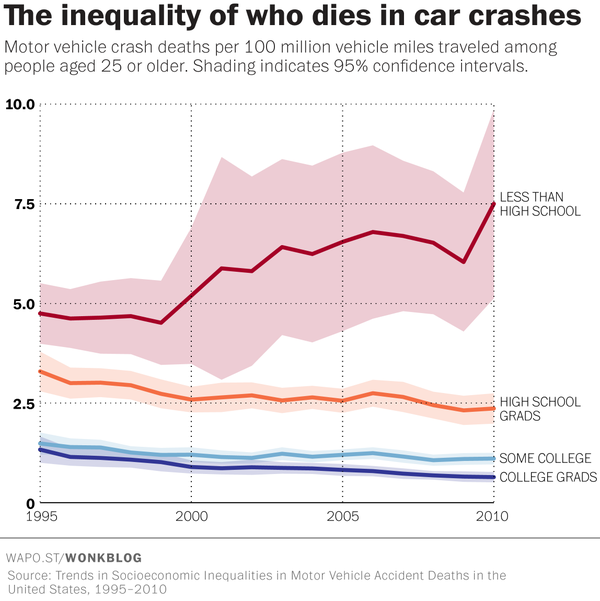
The hidden inequality of who dies in car crashes

Emily Badger has written an interesting piece on The Washington Post covering a recent study that discuss socioeconomic inequalities in car crashes in the US between 1995 and 2010.


Wednesday, June 3, 2015

Brazil's Income Inequality Compared Globally

Brazil is internationally famous for a few things, one of them is having one of the highest levels of income inequality. The good news is that inequality is falling in the country and in Latin America more generally. Here is a nice article on income inequality in Brazil and the relatively small but still important role of conditional cash transfer programms  (ht Renato Saboya).


Here are some more info on the historical evolution of income inequality in Brazil: An interactive chart (by Max Roser), and this interesting chart showing the relation between GDP and Gini index during each presidential term since the 1980s, published Alberto Cairo in his recent book.

image credit: Alberto Cairo

Related Links:

Thursday, April 16, 2015

Geographical Variations in Equality of Opportunity

Raj Chetty has been leading a tremendously important and (already influential) research project on Social Mobility and the geographical variations in equality of opportunity in the US.

Among the main findings, social mobility is found to vary dramatically across US cities.  These geographical differences are correlated with five factors: segregation, income inequality, local school quality, social capital, and family structure. Check one of their papers, below. The website of the project is here, with links to interactive map/chartthe data used in the project etc.


Chetty, R., et al. (2014). Where is the land of opportunity? The geography of intergenerational mobility in the United States (No. w19843). National Bureau of Economic Research.

[image credit: Chetty et al 2014]

Abstract:
We use administrative records on the incomes of more than 40 million children and their parents to describe three features of intergenerational mobility in the United States. First, we characterize the joint distribution of parent and child income at the national level. The conditional expectation of child income given parent income is linear in percentile ranks. On average, a 10 percentile increase in parent income is associated with a 3.4 percentile increase in a child’s income. Second, intergenerational mobility varies substantially across areas within the U.S. For example, the probability that a child reaches the top quintile of the national income distribution starting from a family in the bottom quintile is 4.4% in Charlotte but 12.9% in San Jose. Third, we explore the factors correlated with upward mobility. High mobility areas have (1) less residential segregation, (2) less income inequality, (3) better primary schools, (4) greater social capital, and (5) greater family stability. While our descriptive analysis does not identify the causal mechanisms that determine upward mobility, the publicly available statistics on intergenerational mobility developed here can facilitate research on such mechanisms.

Friday, January 30, 2015

Geographic Effects on Intergenerational Income Mobility

Another paper to my never ending reading list (ht Flavia Feitosa)

Rothwell, J. T., & Massey, D. S. (2015). Geographic Effects on Intergenerational Income Mobility. Economic Geography, 91(1), 83-106. Ungated version here.

Abstract:
Research on intergenerational economic mobility often ignores the geographic context of childhood, including neighborhood quality and local purchasing power. We hypothesize that individual variation in intergenerational mobility is partly attributable to regional and neighborhood conditions—most notably access to high-quality schools. Using restricted Panel Study of Income Dynamics and census data, we find that neighborhood income has roughly half the effect on future earnings as parental income. We estimate that lifetime household income would be $635,000 dollars higher if people born into a bottom-quartile neighborhood would have been raised in a top-quartile neighborhood. When incomes are adjusted to regional purchasing power, these effects become even larger. The neighborhood effect is two-thirds as large as the parental income effect, and the lifetime earnings difference increases to $910,000. We test the robustness of these findings to various assumptions and alternative models, and replicate the basic results using aggregated metropolitan-level statistics of intergenerational income elasticities based on millions of Internal Revenue Service records.

Tuesday, October 14, 2014

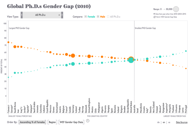
Global Ph.D.s Gender Gap (2010)

Scientific American has recently published an interesting chart showing the gender gap in Ph.D.s across different countries. It's amazing how the distribution varies so much between different fields of study. You should check the interactive version here.