- Where on earth is the Berlin wall? Full story here
- You could fit all the planets of the Solar System within the distance between the Earth and the Moon
- The gradparents of smartcars via MR
- A Visual Survey of Text Visualization Techniques
- A Globe-Spanning Accent Map for the Word 'Potato'
- OECD report: How was life? Global well-being since 1820 via Leo Monasterio
- Varian on Big Data: New Tricks for Econometrics via Gary King
- The Twitter map of the Brazilian Elections
Structured Procrastination on Cities, Transport Policy, Spatial Analysis, Demography, R
Thursday, October 30, 2014
Assorted Links
Marcadores:
Assorted links,
Economics,
GIS,
History,
statistics,
visualizing complexity
Wednesday, October 29, 2014
Manhattan Inside the Grand Canyon
Gus Petro has an amazing artwork to illustrate what it would look like if you dropped Manhattan into the Grand Canyon (via Mark Byrnes).
Petro has another amazing work putting London by the sea. You should check it out and consider this as a Christmas Gift for someone like me. #justsaying
Marcadores:
Art
Monday, October 27, 2014
World population and human capital (webcast)
Heads up:
Prof. Lutz and his team are in the forefront of incorporating educational attainment in population projections and have many influential papers in Nature, Science, PDR, etc. Highly recommended event!
Prof. Wolfgang Lutz (IIASA / Wittgenstein Center) will deliver a public lecture on 'world population and human capital in the 21st century', next week (November 3, 2014 17:00 GMT). This event is also being live webcast on here. The event is organized by the the Oxford Martin School and will be followed by a panel discussion with other demography professors from Oxford.
Prof. Lutz and his team are in the forefront of incorporating educational attainment in population projections and have many influential papers in Nature, Science, PDR, etc. Highly recommended event!
ps. By the way, you might like this interactive population pyramids of population projections and education composition.
Marcadores:
Demographic Trends,
Education
Saturday, October 25, 2014
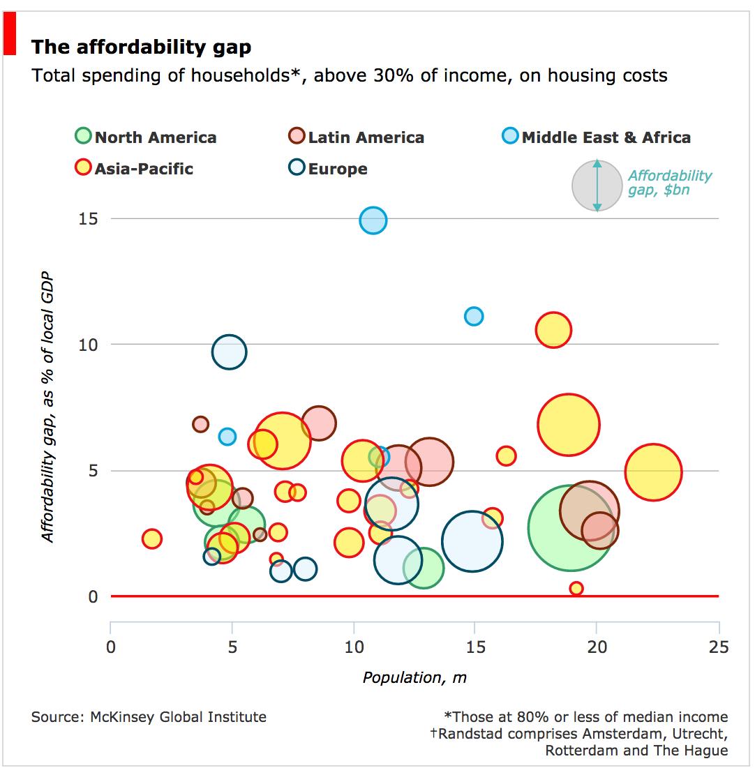
Which cities have least affordable housing?
A new report by McKinsey Global Inst. compares housing affordability across 100 cities. HT/ the Daily Charts team at The Economist, who came up with a nice interactive chart.
Marcadores:
Housing
Wednesday, October 22, 2014
Assorted Links
- What happens when you try to bring your Nobel Prize through airport security?
- 1907-1915 - Russia Before the Revolution, in Color
- Spain is the elevator capital of the world. ht Matt Phillips
- Transport costs and inequalities in vaccine coverage in Africa
- Heads Up: UC Berkeley seeks applications for faculty positions in Transportation Planning and in Housing and Urban Development
- Vertical ballet
- Sad pictures of the rapid deterioration of Detroit, captured by Google Street View
- A camera filter that makes it possible to see carbon emissions, literally
Marcadores:
Art,
Assorted links,
environment,
History,
Transport
Sunday, October 19, 2014
Thursday, October 16, 2014
World Median Ages, and a few papers and links on population aging
Simran Khosla designed this nice map to compare median age across the globe. You may see it in more details in each continent, here. Simran has also done a similar map comparing Life Expectancy at Birth.
And a few papers and links on population aging.
- Map of the Day: Where Seniors Are Moving to in the US
- Is low fertility really a problem? Population aging, dependency, and consumption (ht Bernardo Queiroz)
- The pace of aging: Intrinsic time scales in demography
- Handbook of Sociology of Aging
- Population Change among the Elderly: International Patterns
- The dependence burdens of aging babyboomers: a cross-national view
Marcadores:
Aging
Tuesday, October 14, 2014
Global Ph.D.s Gender Gap (2010)
Scientific American has recently published an interesting chart showing the gender gap in Ph.D.s across different countries. It's amazing how the distribution varies so much between different fields of study. You should check the interactive version here.
Marcadores:
Education,
Inequality
Spatial income inequality in Brazil, 1872–2000
Reis, E. (2014). Spatial income inequality in Brazil, 1872–2000. Economia,15(2), 119-140.
*Thanks Leo Monasterio for the tip.
Abstract:
*Thanks Leo Monasterio for the tip.
Abstract:
The paper provides historical perspectives on spatial economic inequalities in Brazil making use of a database on Brazilian municipalities from 1872 to 2000. A suit of maps and graphs describe the geographic factors shaping the historical development of the Brazilian economy highlighting the role of transport costs and its consequences for the spatial dynamics of income per capita and labor productivity. The remaining of the paper estimates econometric models of growth convergence for municipal income per capita and labor productivity. From 1920 onwards analyses are refined, firstly, by disaggregating the models for urban and rural activities; secondly, by assuming spatial correlation among variables of the model; and, thirdly, by enlarging the model to take account of the long run determinants of spatial growth convergence. Empirical results endorse the historical preeminence of geographic factors – in particular accessibility and transport conditions – as opposed to institutional conditions. The conclusion summarizes the results and proposes research extensions.
Marcadores:
Brazil,
History,
Inequality,
Prata da Casa
Sunday, October 12, 2014
DeadLine, personal note
Always keep it in mind and you won't need to kill yourself for it.
My working soundtrack:
Marcadores:
Academic writing,
Message of the Day
Wednesday, October 8, 2014
Tuesday, October 7, 2014
Assorted links
- Nobel Prize in Physiology or Medicine awarded for locating brain’s GPS (via Anastasios Noulas)
- Japan's Shinkansen bullet train marks 50th anniversary
- AC/DC + Bee Gees mashup
- 3 PostDoc positions at the Center for Metropolitan Studies in Sao Paulo (USP/Brazil)
- Historical Slang Terms For Having Sex since 1351
- Confronting Urban Planning & Design with Complexity: round table with M. Weinstock, M. Batty & Gert de Roo
- The 2014 Sony World Photography Awards Shortlist
- Germany removes University Fees
[image credit:? ]
Marcadores:
Assorted links
Monday, October 6, 2014
Monitoring Urban Greenhouse Gas Emissions from Space
This part of a larger project by NASA to develop robust methods for assessing carbon emissions in the world’s largest cities, including Los Angeles, Sao Paulo, Paris. Click here to read more about the Megacities Carbon Project.
[image credit: Megacities Carbon Project]
Marcadores:
environment
Saturday, October 4, 2014
São Paulo from above (and its parking reform)
If you're interested in parking policies and urban planning, check this post by Paul Barter on the parking reform that is going on in São Paulo.
Even if you're not interested in this topic, I'm sure you'll like this picture (which I saw in Paul's post).
Marcadores:
Parking,
Urban Picture
Brazilian Elections
Big day for Brazil tomorrow with the elections. It's hard to say we don't have a solid democracy.
Thursday, October 2, 2014
How to make your pie chart less terrible
The team at Darkhorse Analytics have already shared a nice tip for how to make tables less terrible. Now it is time to 'improve' your pie charts!
Marcadores:
Academic writing,
Chart of the Day
Subscribe to:
Comments (Atom)


