Showing posts with label Polycentricity. Show all posts

Monday, May 11, 2015

A Simple Index to compare Urban Centrality: Mono vs Polycentric Cities

warning: this post contains self-promotion.

Pereira, R. H. M., Nadalin, V., Monasterio, L., Albuquerque, P. H. M. (2013). Urban Centrality: A Simple Index. Geographical Analysis. doi:10.1111/gean.12002
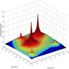
Abstract: This study introduces a new measure of urban centrality. The proposed urban centrality index (UCI) constitutes an extension to the spatial separation index. Urban structure should be more accurately analyzed when considering a centrality scale (varying from extreme monocentricity to extreme polycentricity) than when considering a binary variable (monocentric or polycentric). The proposed index controls for differences in size and shape of the geographic areas for which data are available, and can be calculated using different variables such as employment and population densities, or trip generation rates. The properties of the index are illustrated with simulated artificial data sets and are compared with other similar measures proposed in the existing literature. The index is then applied to the urban structure of four metropolitan areas: Pittsburgh and Los Angeles in the United States; São Paulo, Brazil; and Paris, France. The index is compared with other traditional spatial agglomeration measures, such as global and local Moran's I, and density gradient estimations. 

Here is the ungated versionn of the paper. 

Friday, May 2, 2014

Urban Density Patterns in 9 Global Cities

Here is a nice 'chart' comparing population density patterns across nine global cites. The chart is part of a broader analysis by the LSE Cities programme and their not so new  project Urban Age.


[Click on the image to enlarge it]
[image credit: LSE Cities]


Related Links:

Friday, June 7, 2013

Growth and change in metropolitan form

The City Form Lab (SUTD/MIT) has a research project on measuring urban expansion, particularly focused in East Asia. They have recently published the 'Progress report on urban form and land use measures'. After scanning the report, I'm definitely adding it to my reading list.


[Image Credit: SUTD City Form Lab]

Tuesday, October 11, 2011

Urban Primacy

Another post inspired by Phil McDermott, now with some charts on Urban Primacy.

Urban Primacy indicates to what extent economic development is concentrated in a few cities (population, economic activities, services, etc.). It's all about Christaller's Central Place Theory and Agglomeration Economies!

Phil McDermott says: “Excessive primacy may increase economic volatility because the contrast between a rich centre and poor periphery is politically destabilising. One centre dominating financial, human, and intellectual resources may also increase national vulnerability to structural decline.“ One should also note that excessive primacy can also mean excessive concentration of opportunities and public services. And that's a classic starting point for the debate over balanced urban networks and polycentrism.

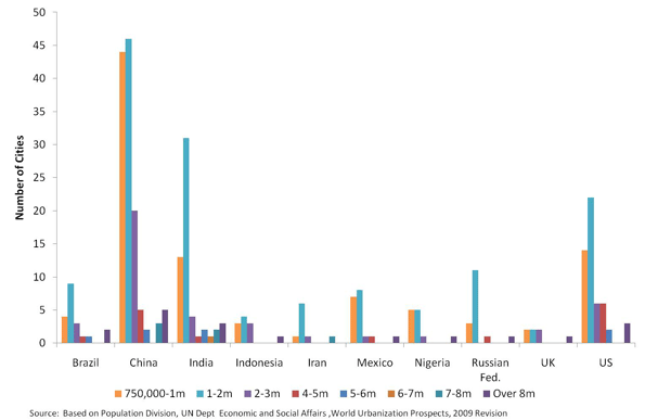
Number of Cities by Size Category (2010)
[image credit: via Cities Matter]


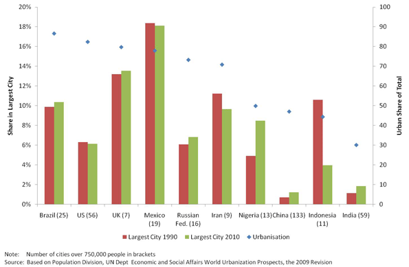
Population Share of Largest City, Ten Nations, 1990 and 2010
[image credit: via Cities Matter]


Share of national GDP and Population of selected cities
Source: World Bank, 2007


*** And here you have a peculiar way to visualize urban hierarchy in Brazil.


Soundtrack for this post: Clapton

Tuesday, January 18, 2011

Assorted links on Chinese Urbanization

  1. Urban China in 30 frames. Here. (via Moving Cities)
  2. The new issue of the Journal of Transport and Land Use (JLUT) focuses on China. Here!

  3. Dan Steinbock on Chinese urbanization and labor force supply. Here.

    excerpt: "The urbanization that took almost a century in the West is occurring in a decade or two in China. In 1979, Shenzhen was still a poor fishing village with some 20,000 inhabitants. In 2009, it had a population of 9 million, and income per capita exceeded $13,600, only $3,000 less than in Taiwan or South Korea."

  4. Lisa Gu on possible urban decentralization in China. Here.
    excerpt: "The shifts in the value of a hokou parallels another interesting shift: many migrant workers are returning to their hometowns much earlier. In the previous years, migrant workers would usually return home right before Lunar Chinese New Year, which typically falls in February, but a large number of them have started to return home in December this year. // The driving factor behind this change is that the cost of living in the cities has risen so dramatically over the past few years, and the money migrant workers earn barely covers their living costs. // Although China’s urbanization will likely continue, the patterns might increasingly be to smaller cities and towns. In this sense, China’s development may, sooner than any expected, begin to take on the dispersion pattern that has occurred in the Western countries for more than a half century.

Thursday, December 16, 2010

Population dispersion infographic

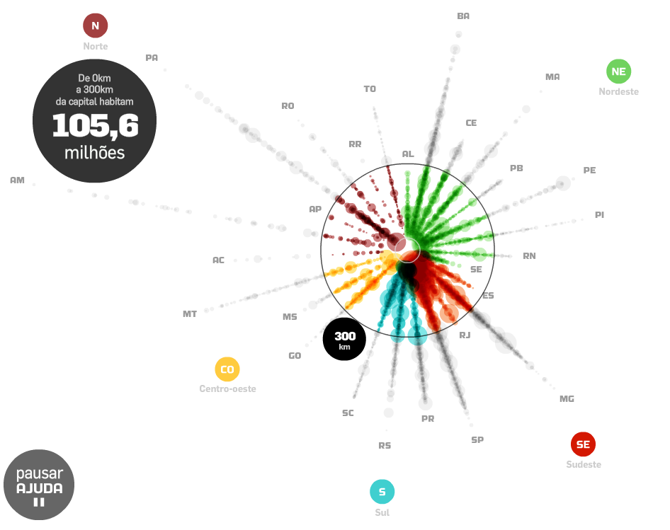
This infographic shows the municipalities population distribution in relation to the distance from the capitals of Brazilian states (preliminary data from Census 2010)*.

Move the mouse over the points /stantes/regions to explore them. You can also click and drag the outer circle to calculate how many live in a range of (i.g.) 300 km from the capitals.

Thanks Prof. Romulo Krafta for the tip.

*It's a peculiar way to visualize urban hierarchy as well.

(By Carlos Lemos via Estadão)

Monday, August 16, 2010

NY towards polycentricity (?)


The US Bureau of the Census has just released detailed commuting trip flow tables (it covers 2006 to 2008). The point that called my attention:
  • Jobs-Housing Balance (“Manhattan has 2.71 jobs for every resident worker. It contrasts with employment the rest of the the city, where the jobs-housing balance at the county level is 0.67, the lowest in the metropolitan area”), and yet a Highly Decentralized Metropolitan Area (“Approximately 74% of employment is outside Manhattan and the jobs are comparatively evenly dispersed among the sectors”).
You can read a more detailed analysis at New Geography.