In a brilliant artistic performance, Simon Weckert generated virtual traffic jams in Google Maps by pulling a wagon full of smartphones. HT Steven Crowley.
Showing posts with label Congestion. Show all posts
Showing posts with label Congestion. Show all posts
Monday, February 3, 2020
Wednesday, November 6, 2019
Positive thinking
Induced demand and the Black Hole Theory of Highway Investment
1970: One more lane will fix it.— Urban Planning & Mobility (@urbanthoughts11) November 4, 2019
1980: One more lane will fix it.
1990: One more lane will fix it.
2000: One more lane will fix it.
2010: One more lane will fix it.
2020: ?pic.twitter.com/NjS1IPORG2
via @avelezig

Monday, May 27, 2019
How congestion pricing works in London and how it could soon work in NYC
New York city is closer than ever to adopt congestion pricing. This could be a major change in how they address their transportation challenges and fund public transport. A team at Vox made an informative video about this, and they asked the sharp Nicole Badstuber (Twitter) to explain how congestion pricing works in London. London started charging private vehicles to enter the city center in 2003. Last month they enacted the London’s ultra-low emission zone, which adds another charge for most vehicles manufactured before 2015.
Wednesday, November 21, 2018
Widening roads to reduce congestion is like loosening the belt to tackle obesity
A gentle reminder that widening roads to reduce congestion is like loosening the belt to tackle obesity *
Related links:
* UPDATE: Apparently, this metaphor was originally used by the urban planner Lewis Mumford in 1955. “Building more roads to prevent congestion is like a fat man loosening his belt to prevent obesity”.
Our annual reminder: Widening 👏 highways 👏 doesn't 👏 work 👏— Streetsblog USA (@StreetsblogUSA) November 21, 2018
This freeway -- LA's 405 -- was JUST widened at a cost of $1.6 billion. pic.twitter.com/vFSTmfdhnC
Related links:
* UPDATE: Apparently, this metaphor was originally used by the urban planner Lewis Mumford in 1955. “Building more roads to prevent congestion is like a fat man loosening his belt to prevent obesity”.
Friday, June 29, 2018
Quote of the Day: induced demand
“We assume that car use is an incompressible liquid that must be routed somewhere. But it’s more more like a gas that fills whatever space it's given.” Ian Lockwood, HT Taras Grescoe

Wednesday, April 11, 2018
Assorted links
- Automation and AI will increase spatial/regional inequalities. Paper by Morgan Frank and colleagues
- Explore, select and download data of the global population projections by age, sex and education, a great collaborative work of researchers from the Wittgenstein Centre for Demography and Global Human Capital
- Greyhound: a powerful platform to interactively explore and analyze massive point clouds with Trillions of points in the browser, via Howard Butler
- The dynamical structure of political corruption networks. A paper by Haroldo Ribeiro, Luis Alves et al., analyzing 27 years of political corruption scandals in Brazil
- Citywide effects of high-occupancy vehicle restrictions: Evidence from “three-in-one” in Jakarta, by Rema Hanna et al.
- Want to find statistically significant hierarchical modules in weighted networks? paper here and code here, by Tiago Peixoto, who is the author of the graph-tool Python library

Wednesday, June 7, 2017
The Fundamental Law of Road Congestion
Duranton, G., & Turner, M. A. (2011). The fundamental law of road congestion: Evidence from US cities. The American Economic Review, 101(6), 2616-2652. Ungated version here.
Abstract:
This paper reminds of the Black Hole Theory of Highway Investment, which we posted about a while ago.
Abstract:
We investigate the effect of lane kilometers of roads on vehicle-kilometers traveled (VKT) in US cities. VKT increases proportionately to roadway lane kilometers for interstate highways and probably slightly less rapidly for other types of roads. The sources for this extra VKT are increases in driving by current residents, increases in commercial traffic, and migration. Increasing lane kilometers for one type of road diverts little traffic from other types of road. We find no evidence that the provision of public transportation affects VKT. We conclude that increased provision of roads or public transit is unlikely to relieve congestion
This paper reminds of the Black Hole Theory of Highway Investment, which we posted about a while ago.

Friday, November 25, 2016
Carmageddon and Jamzilla in Los Angeles
I have already posted in the blog about the The Black Hole Theory of Highway Investment. For this matter, LA's 405 freeway is quite an iconic case as it has been the stage of 'Carmageddons' and 'Jamzillas' over the years.
Happy thanksgiving to our friends in LA.
#MannequinChallenge? Traffic nearly at a standstill on the 405 Freeway https://t.co/yfahcIv8AR pic.twitter.com/ZQndXJwEA3— ABC7 Eyewitness News (@ABC7) November 23, 2016
Related links:
Thursday, October 27, 2016
The impact of public transport on traffic congestion
"... we find that average highway delay increases 47 percent when transit service ceases."
This is from a 2014 paper by Michael Anderson (Berkeley), analyzing the impacts of public transport on traffic congestion in Los Angeles. An ungated working-paper version is available here. Via Renato Vieira.
Anderson, Michael L.. 2014. "Subways, Strikes, and Slowdowns: The Impacts of Public Transit on Traffic Congestion." American Economic Review, 104(9): 2763-96.
Abstract
Public transit accounts for 1 percent of U.S. passenger miles traveled but attracts strong public support. Using a simple choice model, we predict that transit riders are likely to be individuals who commute along routes with severe roadway delays. These individuals' choices thus have high marginal impacts on congestion. We test this prediction with data from a strike in 2003 by Los Angeles transit workers. Estimating a regression discontinuity design, we find that average highway delay increases 47 percent when transit service ceases. We find that the net benefits of transit systems appear to be much larger than previously believed.
Despite this really interesting finding, I just would like to note that the main purpose of public transport is not to reduce congestion, as many politicians and the general media like to think. The purpose of public transport is to help people to access activities and opportunities. Although this might sound a subtle difference for some people, this difference has serious implications for how one should plan and evaluate transport policies.
Thursday, May 12, 2016
Traffic Jam without bottleneck

Last week, I posted a link to a terrific visual and interactive explanation of the difference between Gridlock and Bottlenecks.
I guess one could say gridlocks are one of the causes of traffic jam when there is no bottleneck. This video shows a real demonstration of this. (via Gonçalo Correia)
Monday, October 12, 2015
Build and they will come, or The Black Hole Theory of Highway Investment
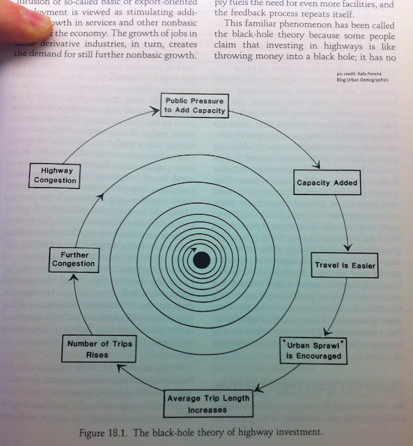
"Initial investments in improved highway facilities result in greater ease of travel and hence altered travel patterns, including an increase in average trip length and in the number of trips being made. Over time, as shown in Figure 18.1, this increased demand stimulated by the initial investment in increased transport supply fuels the need for even more facilities, and the feedback process repeat itself. This familiar phenomenon has been called the black-hole theory because some people claim that investing in highways is like throwing money into a black hole" (Plane, 1995 p.439)

Reference:
- Plane, D. A. (1995). Urban transportation: policy alternatives. In Hanson & Giuliano (Eds.) The geography of urban transportation. (2nd ed.) New York ; London: Guilford Press.
Thursday, February 27, 2014
Urban Picture
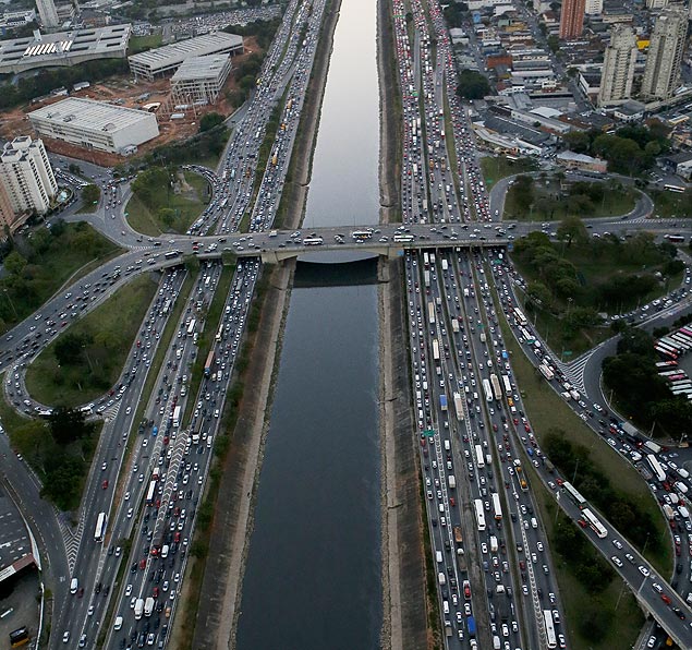
São Paulo, Marginal Pinheiros in a regular Wednesday
Soundtrack: Bogotá, by Criolo

obs. This one I took from Transportblog! (great blog, by the way) and it's in Auckland (NZ), but it would perfectly fit São Paulo streets today!
Sunday, February 16, 2014
A Historic Traffic Jam: the "H-Day" in 1967
When was the last time you've heard about a traffic jam in which people were actually happy to participate?


In his amazing book 'Traffic: Why we drive the way we do (and what it says about us)', Tom Vanderbilt gives us a glimpse of the "H-Day", when everyone in Sweden started driving on the opposite side of the road. I reproduce here a snippet of the book and two great pictures taken on "H-Day":
Just before dawn on Sunday, September 3, 1967, there was an unusually festive air in the streets of Stockholm. Cars honked, passersby cheered, people gave flowers to police officers, pretty girls smiled from the curb. The streets were clogged with cars, many of which had been waiting for hours to participate in a historic traffic jam. [...] At the moment the bell schimed for six o'clock, Swedes began driving on the right.It had taken years of debate, and much preparation, to get to this point. [...] Undeterred, backers of right-side driving finally got a measure approved by the government in 1963.As "H-Day" (after hoger, the Swedish word for "right") approached, the predictions of ensuing chaos and destruction grew dire. [...] And what happened when Swedes started driving on the other side of the road, many for the first time in their lives? The roads got safer. [...] Remarkably, it was not just for a few days, or even weeks, after the change over that Sweden's roads were safer. It took a year before the accident rate returned to what it had been the year before the changeover.


[images credit: ? via wired]
Related Links:
Wednesday, December 11, 2013
Assorted Links
- Road pricing: What’s not to love?
- Top 20 things politicians need to know about science and Top 20 things scientists need to know about policy-making (ht Paulo Nascimento)
- Turning-point years in history according to the most frequent dates used dissertation titles
- Up all night to get data, a music parody
- San Francisco Aerial Views. 1937-1938
- Urban street networks, a comparative analysis of ten European cities
- Declining fertility rates will transform the Asian family
- Coldest spot on Earth identified by satellite (minus 93.2 Cº)
- Snapshot: Global Migration
- African polygamy over space and time

Sunday, December 1, 2013
Assorted Links
- The world's tallest slum (via Pedro Souza)
- Observing the Earth with Incredible Satellite Photos
- Tweet City: Building Heights by Number of Tweet
- Things I'd rather be doing
- The Gap Between Schooling and Education
- Is Regional Policy a Waste of Time? (via Leo Monasterio)
- Driverless vehicles are not going to solve congestion problems
- A scary time-lapse map of the 2053 nuclear explosions which have taken place between 1945 and 1998
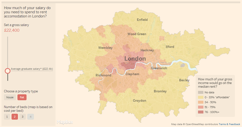
- How much of your salary would you need to spend to rent a room in London?
[Image Credit: FT]
Wednesday, May 15, 2013
A spreadsheet to calculate congestion charge
For those interested in transport modelling and congestion pricing, here is a piece in Wired about Komanoff 's spreadsheet to calculate congestion charge. He has been working for three years now on the Balanced Transportation Analyzer, an Excel spreadsheet proposed to model every aspect of New York City transportation (I thank Fabio Storino for the pointer).
The spreadsheet is quite impressive as for the amount of input data it demands. However, I'm not familiarized with transport modelling, so I'm in no position to have an opinion on this spreadsheet. I'd rahter have some experts' opinions published in scientific journal assessing it.
ps. I confess though I asked myself: why 'Excel' ?! This is too vintage.
And here is a 15-minute video where Komanoff explains the whole idea of the project.
The spreadsheet is quite impressive as for the amount of input data it demands. However, I'm not familiarized with transport modelling, so I'm in no position to have an opinion on this spreadsheet. I'd rahter have some experts' opinions published in scientific journal assessing it.
ps. I confess though I asked myself: why 'Excel' ?! This is too vintage.
Tuesday, March 12, 2013
Crowdsourcing road congestion data
Nathan Yau points out to this interactive map showing county-level commute time estimates for 2011 in the US. The data source is the American Community Survey organized by the United States Census Bureau. Pretty good job!

Now imagine if you could have acess to real time data on traffic conditions on arterial roads in several cities around the globe. There is one company that generates these data. I know what you're thinking: "Damn these guys from Google are awesome!"
Acutally this is not a new project. Google has started it aroud 2009 and now it covers. several cities around the globe. They basically track anonymous locations from smartphones to gauge traffic conditions in real time:
When we combine your speed with the speed of other phones on the road, across thousands of phones moving around a city at any given time, we can get a pretty good picture of live traffic conditions. We continuously combine this data and send it back to you for free in the Google Maps traffic layers. It takes almost zero effort on your part — just turn on Google Maps for mobile before starting your car — and the more people that participate, the better the resulting traffic reports get for everybody.
The Google Maps Traffic Layer (web version) also inclues traffic prediction for any day of the week and time of the day, based on past conditions. Neat! Now it should be very interesting to compare/validate Google's traffic data to "real data" from more traditional sources.
Any volunteers?
Saturday, February 23, 2013
The unintended consequence of licence plate schemes
A couple of cities such as São Paulo, Bogota and Mexico City have already tried to cut down on traffic using licence plate schemes. Needless to say they have achieved limited success if any .
In this Freakonomics episode Dubner and Levitt talk about the universal law of 'unintended consequence' and how it applies to such schemes.
Monday, May 21, 2012
Assorted Links
- Population Association of America (PAA) on the elimination of the American Community Survey
- Prof. Michael Sandel will be in London for a public lecture at St. Paul's Cathedral on next Wednesday (I have just received my ticket!)
- Intellectuals go to the beach: Albert S. (funny pictures)
- Dramatic Differences in Childbearing by Age in U.S., Japan, and South Korea
- Mind the Map: Inspiring art, design and cartography (exhibition at the London Transport Museum)
- Dramatic Changes on London Streets in the Congestion Pricing Era
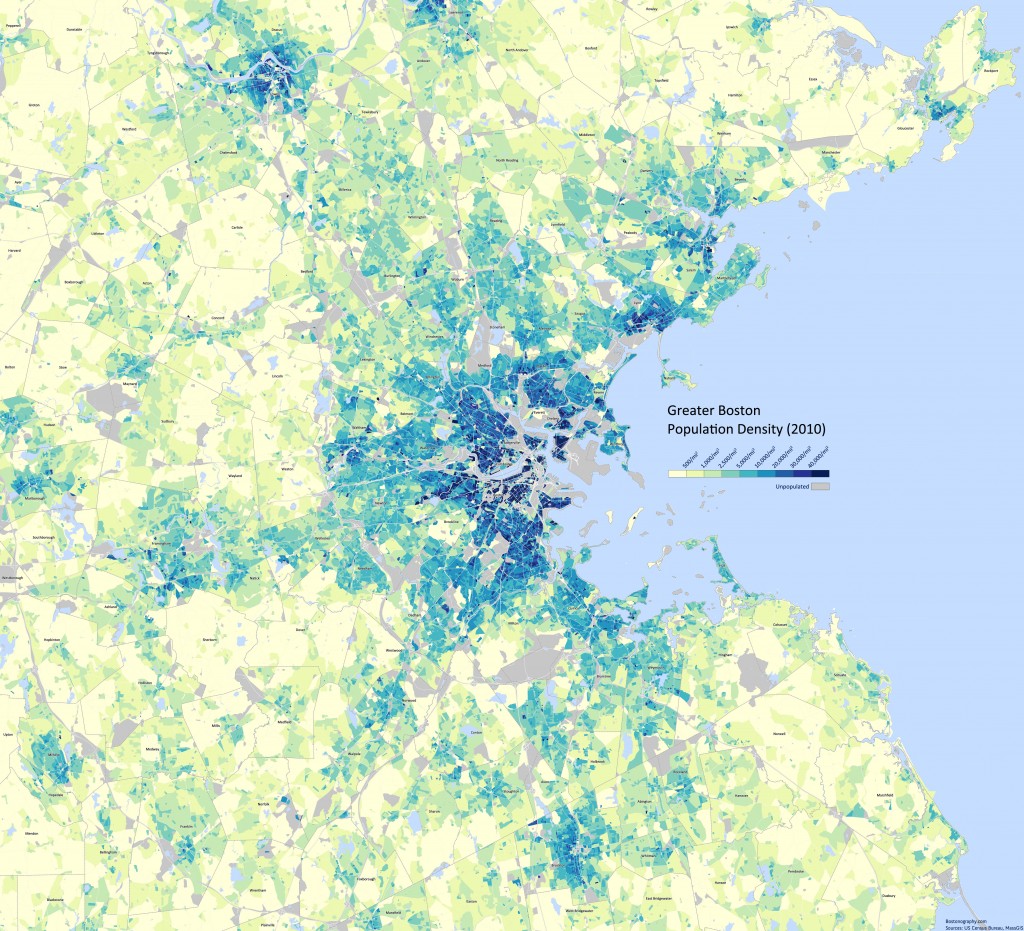
- A good post on population density at Bostonography
Population density in the Greater Boston area 2010.
Monday, January 30, 2012
Replay: Counterintuitive trues about urban transport
 Enrique Peñalosa (former mayor of Bogotá) presented a pleasant lecture at LSE titled: “Politics, Power, Cities”. Listen to podcast here (approx 91 min).
Here are some interesting snippets (They might look obvious to some of you. But do they look obvious to you mayor?)
- What creates traffic is not the number of cars, is the number of trips and the length of trips.
- Mobility and Traffic Jams are total different problems that require different solutions. Reducing car use is different than solving Traffic Jams.
- To solve Traffic Jams is, in fact, to facilitate car use.
- The only way to solve Mobility is with public transport. This will solve Mobility but not Traffic Jams.
- The only way to solve Traffic Jams is restricting car use. And the most obvious way to restrict car us is restrict parking.
- To park is not a Constitutional right anywhere.
- For public transport the most important thing is Density.
*ps2. He didn't say much (nothing) about land use... I missed that.
Subscribe to:
Posts (Atom)