- All streets (Ben Fry) -All of the streets in the lower 48 United States: an image of 26 million individual road segments. Now that's a map I would love to see converted into an axial map!
 Some really old maps of South London [Space Syntax researchers, how about doing a comparative historical analysis?] via Nettoworks.
- Have you heard about Typographic Maps? Depicted cities with textual elements! And you thought the creation of an axial map was laborious. Via Jonathan Crowe.
- 3D Space Syntax (ok, that's new for me!)
Structured Procrastination on Cities, Transport Policy, Spatial Analysis, Demography, R
Monday, February 28, 2011
Assorted links on Space Syntax
Thursday, February 24, 2011
Monday, February 21, 2011
Labor Force Projections in Brazil

Brazil has been experiencing a strong economy in the last few years. Even though it might seem a paradox, this recent economic growth pace has been a main concern for some analysts. One critical issue is the doubt whether Brazil is going to have enough qualified labor force to meet market’s demand if economic growth pace continues as observed in recent years. Added to this, another reason for uncertainty is that Brazil is now facing an accelerated aging process.
So, for the last months, I have been engaged in a research project at Ipea called "Scenarios for the Brazilian labor market". I'm helping to build a demographic a projection methodology of skilled labor force suitable for Brazilian data. We are projecting as a first exercise the population with a bachelor's degree in engineering and related areas (time horizon 2020).
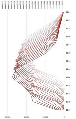
So I've decided I will try to post about this project whenever possible and maybe you guys can come up with some suggestions. This first post focuses on the male engineers captured by the Census 2000.
This chart shows the evolution of the population (male engineers) pyramid from 2000 to 2020. Darker lines represent the earlier projection years.
Wednesday, February 16, 2011
Short interview with Glaeser
(
Other interesting post: Should there be a “proper density”?
Friday, February 11, 2011
New links to Online Databases
Tuesday, February 8, 2011
Call for papers (and people) - Updated!
Call for papers:
ISUF 2011 - 18th International Seminar on Urban Form.
51st European Congress of the Regional Association International
Submission Deadline: 4th of March 2011
ISUF 2011 - 18th International Seminar on Urban Form.
Submission Deadline (abstract): 25 February 2011
Spaces and Flows Conference 2011.
Spaces and Flows Conference 2011.
Submission Deadline: 4th of March 2011
Submission Deadline: 21 February 2011
58th Annual North American Meetings of the RSAI / 6th Meeting of the Urban Economics AssociationThe abstract/session submission portal will open in April 2011
World Symposium on Transport and Land Use Research (WSTLUR)
Submission Deadline: December 31, 2010 (Missed that)
XI Jornadas Argentinas de Estudios de Población
Submission Deadline: 15 april 2011
European Doctoral School of Demography (EDSD)
Submission Deadline: 31 January 2010 (Missed that)
Call for people:
European Doctoral School of Demography (EDSD)
Application deadline: 15 April 2011. - [thanks Joice Melo Oliveira]
Several summer courses 2011 at the IMPRSD - International Max Planck Research School for Demography
Application deadline: 31 March 2011 - [thanks Joice Melo Oliveira]UPDATED: The MIT Portugal Program announces its call for applications for the PhD in Transportation Systems (and Master in Complex Transport Infrastructure Systems).
Applications Deadline: 28 February for the PhD course, and until March 31 for the Master’s Course
The closing date for applications is 10th March 2011.
El Centro de Estudios Demográficos, Urbanos y Ambientales (CEDUA) de El Colegio de México convoca a interesadas e interesados de cualquier nacionalidad al concurso para contratar un profesor-investigador.
Thursday, February 3, 2011
Cities at Night
The NASA Earth Observatory has a huge 'collection' of beautiful photographs. This collection includes some photographs of cities at night taken by astronauts from the International Space Station.
Astronauts circling the Earth have the wonderful vantage point of observing the nighttime Earth from 350-400 kilometers above the surface, taking in whole regions at once. Onboard cameras and a bit of experimentation allow astronauts to take highly detailed images of our cities at night and share them with the rest of us.
Brasília at night is the current image of the week. They say that "Brasília is widely considered to be one of the best examples of 20th century urban planning in the world." I'll try to take that as a complement.
(all photos credit: Gateway to Astronaut Photography of Earth)
Some other photographs: Montreal, Dubai, Las Vegas, Los Angeles (this video is great), London, Houston, Northern China, Buenos Aires, São Paulo. [Hat tip to The Map Room]
And my favorite ones:

